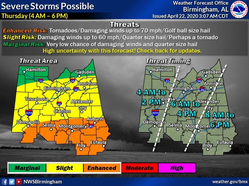
SYLACAUGA, Ala. – The National Weather has made slight modifications to its Thursday severe weather prediction.
While Sylacauga and Talladega Co. are still in the slight risk area, the area classified as enhanced risk has moved north.
Storms are now predicted to come a few hours earlier than originally. The window or severe weather in Talladega Co. is 6:00 a.m. to 4:00 p.m.
View the NWS Facebook post below:
The full post reads:
“Main adjustments from yesterday: Enhanced Risk has been adjusted a bit to the north, and severe threat time frame has been expanded earlier to 4am. Reason being, is that some storms with large hail and damaging winds will be possible between 4am and 8am. The tornado threat early on will be low, as the most unstable air at the surface to support that threat won’t be present across Central Alabama at this time.
High Uncertainty Regarding the Afternoon Forecast: As we go into the afternoon there are MANY factors that will come into play. The biggest factor is what will happen with the widespread showers and storms that will move through during the morning? We’ll have to monitor very closely in regards to what kind of environment that we’ll have late tomorrow afternoon and into the evening. There’s a chance that IF all the ingredients come together and we get afternoon heating following the morning wave of storms, a threat for tornadoes may materialize across southern portions of Central Alabama.
HAVE YOUR PLAN READY: Even though there’s high uncertainty in the forecast at the current time, folks should still be prepared for the potential of severe storms tomorrow. Remember – straight-line winds up to 70mph can be just as destructive and more widespread as tornadoes – and may very well be the primary hazard with this event. Take Severe Thunderstorm Warnings Seriously!! As always, we’ll keep you updated with the latest forecast trends!”


