

CENTRAL ALABAMA – Living in Central Alabama has left us wondering about a winter storm heading south. There is still a very slight chance of snow during the night on Sunday, Jan. 25, but the real threat would be a full day of rain meeting frigid Arctic cold that descends upon us overnight.
Strong, gusty winds will only add to the issues of frigid cold and random ice patches on the roads Monday morning.
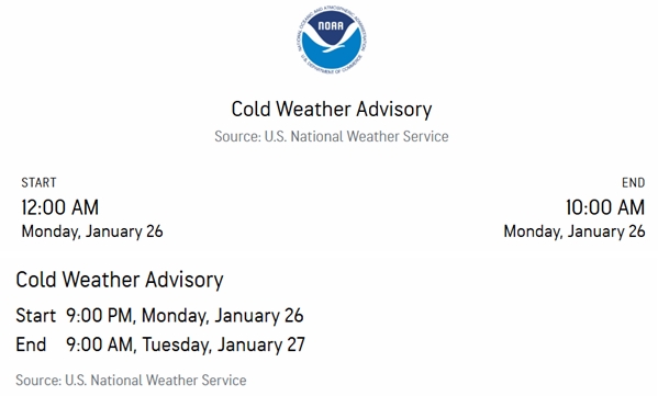
The National Weather Service has issued a pair of Cold Weather Advisories. The first runs from midnight Sunday night through 10:00 a.m. on Monday morning, with temperatures dropping from the mid-20s at 12:00 a.m. to a low of 18 degrees in the 8:00 a.m. hour. We should pass the freezing mark around noon and remain in the 30s until dark.
For this first Cold Weather Advisory, very cold wind chills as low as zero are expected expected. Frostbite and hypothermia will occur if unprotected skin is exposed to these temperatures. An extended period of subfreezing temperatures could cause pipes to burst.
Use caution while traveling outside. Wear appropriate clothing, a hat, and gloves. Keep pets indoors as much as possible. Make frequent checks on older family members, friends, and neighbors. Ensure portable heaters are used correctly. Do not use generators or grills inside. To prevent freezing and possible bursting of pipes, they should be wrapped, drained, or allowed to drip slowly.
With a cold day on Monday, the second Cold Weather Advisory starts at 9:00 p.m. Monday night and runs through 9:00 a.m. Tuesday, Jan. 27. The temperature is expected to drop into the mid-teens near sunrise Tuesday, but winds should be much milder than the previous night.


